About This Map
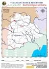
A Telangana state outline map showing the state's two great river systems — the Godavari and the Krishna with all their principal tributaries — in bold blue, with every major reservoir and dam impoundment marked in red against district boundaries as of 2025. Twelve blank label boxes are printed along the bottom of the sheet so the map doubles as a practice exercise: identify each marked water body and write it in. Covers Nizam-era works like Nizam Sagar and Osman Sagar, the mid-century giants Nagarjuna Sagar and Sriram Sagar, and the recent Kaleshwaram barrage chain on the Godavari.
Nearly every dam in Telangana sits on one of just two rivers or their tributaries. The Godavari and its feeders — Pranahita, Manjira, Manair, Kadem, Kinnerasani — drain roughly 79% of the state; the Krishna and its feeders — Bhima, Dindi, Musi, Tungabhadra — drain most of the rest. Fix those two basins in mind and the position of almost every red patch on this sheet becomes predictable. The Kaleshwaram Lift Irrigation Project alone lifts Godavari water through 3 barrages and up the Manair chain into 7 interconnected Link IV reservoirs — a genuinely large sub-network within the Godavari basin, not just the 3 names (Mallannasagar, Kondapochamma Sagar, Ranganayaka Sagar) most lists mention.
Major dams and reservoirs of Telangana, by river basin
Godavari basin (north & east)
| Dam / Reservoir | River | District | Year | Note | Shapefile FID |
|---|---|---|---|---|---|
| Sriram Sagar (Pochampad) | Godavari | Nirmal | 1977 | The lifeline of north Telangana; irrigates the Karimnagar-Warangal-Nizamabad belt | |
| Kaleshwaram (Godavari–Pranahita Confluence) | Godavari–Pranahita confluence | Jayashankar Bhupalpally | The project's namesake — not a dam itself, the point where the Pranahita meets the Godavari, immediately upstream of Medigadda Barrage | 0 | |
| Sripada Yellampalli | Godavari | Peddapalli | 2010 | Feeds Hyderabad drinking water and the NTPC Ramagundam plant · 20.00 TMC gross capacity (Wikipedia infobox) | 4 |
| Medigadda (Lakshmi) Barrage | Godavari | Jayashankar Bhupalpally | 2019 | Head of the Kaleshwaram Lift Irrigation Project · 16.17 TMC gross capacity (Wikipedia infobox) | 1 |
| Annaram (Saraswathi) Barrage | Godavari | Jayashankar Bhupalpally | 2019 | Second barrage of the Kaleshwaram chain · 11.90 TMC gross capacity (Wikipedia infobox) | 2 |
| Sundilla (Parvathi) Barrage | Godavari | Peddapalli | 2019 | Third barrage of the Kaleshwaram chain · 8.83 TMC gross capacity (Wikipedia infobox) | 3 |
| Mallannasagar | Off-river (Kaleshwaram) | Siddipet | 2020 | Largest storage reservoir of the Kaleshwaram network · officially Komuravelli Mallanna Sagar; ~5,865 ha reservoir area | |
| Kondapochamma Sagar | Off-river (Kaleshwaram) | Siddipet | 2020 | Highest-lift reservoir of the project · terminus at 618 m elevation, the chain's highest point; ~1,711 ha reservoir area | |
| Ranganayaka Sagar | Off-river (Kaleshwaram) | Siddipet | 2019 | Kaleshwaram distribution reservoir · officially Sri Ranganayaka Sagar; ~768 ha reservoir area | |
| Nizam Sagar | Manjira | Kamareddy | 1931 | Nizam-era masonry dam, once the largest in the Deccan | |
| Singur | Manjira | Sangareddy | 1989 | Principal drinking-water source for Hyderabad and Secunderabad | |
| Upper Manair Dam | Manair | Karimnagar | Reservoir at the Link III/Link IV junction of the Kaleshwaram chain (india-geodata Bharatmaps_Dams) | 5 | |
| Mid Manair | Manair | Rajanna Sircilla | 2019 | Junction point linking Sriram Sagar and Kaleshwaram | 6 |
| Lower Manair | Manair | Karimnagar | 1985 | Terminal reservoir of the Sriram Sagar canal system | 7 |
| Kaddam Narayana Reddy Project | Kadem | Nirmal | 1958 | Godavari tributary project below the Nirmal hills | |
| Kinnerasani | Kinnerasani | Bhadradri Kothagudem | 1966 | Supplies the Kothagudem thermal station; ringed by its sanctuary | |
| Sammakka Sagar (Tupakulagudem) | Godavari | Jayashankar Bhupalpally | 2022 | Barrage on the lower Godavari | |
| Wyra | Wyra | Khammam | 1930 | One of the older irrigation tanks of the region | |
| Palair | Palair (Krishna canal fed) | Khammam | 1968 | Balancing reservoir on the Nagarjuna Sagar left canal |
Krishna basin (south & west)
| Dam / Reservoir | River | District | Year | Note | Shapefile FID |
|---|---|---|---|---|---|
| Nagarjuna Sagar | Krishna | Nalgonda (shared with Palnadu, AP) | 1967 | The world's tallest and largest masonry dam, 124 m high | |
| Srisailam | Krishna | Nagarkurnool (shared with Nandyal, AP) | 1981 | Major hydro-electric project in the Nallamala gorge | |
| Priyadarshini Jurala | Krishna | Jogulamba Gadwal | 1995 | The first major project on the Krishna as it enters Telangana | |
| Koil Sagar | Peddavagu | Mahabubnagar | 1950 | Small Krishna-basin project of the erstwhile Mahabubnagar district | |
| Musi Project | Musi | Nalgonda | 1963 | Impounds the Musi before it joins the Krishna | |
| Dindi Reservoir | Dindi | Nalgonda | 1943 | Krishna tributary project feeding the Nalgonda uplands |
Hyderabad's own lakes (Musi system)
| Dam / Reservoir | River | District | Year | Note | Shapefile FID |
|---|---|---|---|---|---|
| Hussain Sagar | Musi tributary | Hyderabad | 1563 | Built under the Qutb Shahis; the oldest surviving water body on this map | |
| Osman Sagar (Gandipet) | Musi | Rangareddy | 1920 | Built after the 1908 Musi flood to protect and supply the city | |
| Himayat Sagar | Esi (Musi tributary) | Rangareddy | 1927 | Companion reservoir to Osman Sagar on the parallel Esi stream |
Kakatiya-era heritage tanks
| Dam / Reservoir | River | District | Year | Note | Shapefile FID |
|---|---|---|---|---|---|
| Pakhal Lake | Local stream | Warangal | 1213 | Built by Ganapati Deva; now the core of Pakhal Wildlife Sanctuary | |
| Ramappa (Ramalingeswara) Lake | Local stream | Mulugu | 1213 | Adjoins the UNESCO World Heritage Ramappa temple | |
| Laknavaram | Local stream | Mulugu | 1213 | Kakatiya-era chain tank, now known for its suspension bridges |
Years given are of completion or first impoundment. Nagarjuna Sagar and Srisailam are inter-state projects shared with Andhra Pradesh — the map marks the reservoir spread, part of which lies across the border. Kaleshwaram component reservoirs are lift-fed from the Godavari rather than built across it. Kakatiya-era tank years are approximate (13th century). The 'Shapefile FID' column cross-references BMGT's own Kaleshwaram GIS dataset (01_KLIP_key_structures_pts, points FID 0–7) — scan this page's QR code with that shapefile open in your GIS software to verify a point's real-world identity directly against this table.
Why the drainage divides the way it does
- Telangana slopes north-east. Both the Godavari and the Krishna enter from the west and leave toward the Bay of Bengal, so nearly every tributary on this map flows west-to-east or north-east.
- The Godavari basin covers roughly 79% of the state; the Krishna basin most of the remainder. There is no third major system — a river on this sheet almost always belongs to one of the two.
- The watershed between them runs roughly through the Rangareddy-Nalgonda-Mahabubnagar uplands, which is why Hyderabad's own lakes drain south into the Krishna via the Musi, not north into the Godavari.
The Godavari tributaries, in order downstream
- Manjira - joins near Nizamabad; carries Nizam Sagar and Singur.
- Pranahita - the Godavari's largest tributary, formed by the Wardha, Wainganga and Penganga; joins at Kaleshwaram, right at the Medigadda Barrage.
- Manair - joins near Karimnagar; carries the Upper, Mid and Lower Manair dams.
- Kadem, Peddavagu, Indravati, Kinnerasani, Sabari, Taliperu - the eastern feeders through the forest belt.
Three eras of dam building
- Nizam era (1900s-1940s) - Osman Sagar, Himayat Sagar, Nizam Sagar, Wyra. Masonry gravity dams, built largely for drinking water and flood control after the 1908 Musi flood.
- Post-Independence (1950s-1990s) - Nagarjuna Sagar, Srisailam, Sriram Sagar, Kaddam, Kinnerasani, Lower Manair, Singur, Jurala. Large multipurpose projects: irrigation, hydro-power and industry together.
- Post-bifurcation (2014 onward) - Kaleshwaram: Medigadda, Annaram and Sundilla barrages lift Godavari water up through the Manair chain (Upper/Mid/Lower) into a seven-reservoir Link IV storage network. These are lift projects — water is pumped uphill rather than stored behind a dam built across a river, which is why several of these reservoirs sit nowhere near a river on the map.
The full Kaleshwaram Link IV reservoir chain (7 reservoirs, not just 3)
- Komuravelli Mallanna Sagar (Errapalle, Siddipet) - the network's 'mother reservoir', ~5,865 ha - the largest single reservoir in the chain.
- Kondapochamma Sagar (Bhilampur, Markook mandal, Siddipet) - the chain's terminus and highest point, 618 m elevation, ~1,711 ha.
- Sri Ranganayaka Sagar (Chandlapur, Siddipet) - ~768 ha.
- Anantagiri Reservoir (Ananthagiri, Rajanna Sircilla) - ~883 ha.
- Gandamalla Reservoir (Gandamalla, Yadadri Bhuvanagiri) - a balancing offtake reservoir, ~901 ha.
- Thotapally Balancing Reservoir (Dacharam, Siddipet) - ~274 ha.
- Gouravelli Balancing Reservoir (Gouravelli, Siddipet) - the smallest in the chain, ~86 ha.
Records worth remembering
- Nagarjuna Sagar - the world's tallest masonry dam (124 m) and largest by masonry volume; also the largest reservoir in the state.
- Hussain Sagar (1563) - the oldest water body marked on the sheet, predating every other by over three centuries.
- Kaleshwaram - described as the world's largest multi-stage lift irrigation project when commissioned in 2019.
- Ramappa Lake - the only reservoir on this map adjoining a UNESCO World Heritage Site (Ramappa temple, inscribed 2021).
Tips And Tricks
- Trace the two trunk rivers before marking a single dam. Draw the Godavari across the north and east and the Krishna across the south, and roughly two-thirds of the red patches will already be sitting on a line you have drawn.
- Use the twelve blank boxes at the bottom as a self-test, not a legend. Cover the answers, fill in twelve reservoirs from the marked positions alone, then check — this is exactly the format regional geography questions take.
- Name pairs are the fastest anchors: Nizam Sagar and Singur are both on the Manjira; Osman Sagar and Himayat Sagar are the twin Hyderabad lakes on the Musi and Esi; Nagarjuna Sagar and Srisailam are the twin Krishna giants on the Nallamala gorge.
- The Kaleshwaram reservoirs — Mallannasagar, Kondapochamma Sagar, Ranganayaka Sagar and four more balancing reservoirs (Anantagiri, Gandamalla, Thotapally, Gouravelli) — will look wrong if you expect every reservoir to sit on a river. They don't. Water is lifted to them from the Godavari via the Manair chain, so they appear inland in Siddipet and neighbouring districts, well away from any blue line.
- Learn the Manair chain in order — Upper, Mid, Lower — running down toward Karimnagar. Mid Manair is the pivot that links the older Sriram Sagar canal system to the newer Kaleshwaram network, which is why it appears in questions about both.
- Nagarjuna Sagar and Srisailam are shared with Andhra Pradesh, so their reservoir spread crosses the state boundary on this sheet. Marking them as 'Telangana dams' is only half right — always note them as inter-state Krishna projects.
- Not every red patch is a modern dam. Pakhal, Ramappa and Laknavaram in the Warangal-Mulugu area are 13th-century Kakatiya tanks, still holding water eight hundred years later — a favourite exam link between geography and heritage.
- Own the physical map? Scan the QR code and check the 'Shapefile FID' column in the table below — it cross-references BMGT's own Kaleshwaram GIS point dataset (FID 0 through 7) directly against the barrages and dams named on this page.
Comments & Issue Reporting
Sign in to leave a comment or report an issue with this map.
No comments yet — be the first to share your thoughts.