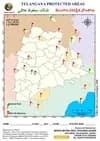
About This Map
A Telangana state outline map for marking the state's full protected-area network — 3 National Parks (green flags) and 9 Wildlife Sanctuaries (red flags) — plotted against district boundaries as of 2025. Two of these sanctuaries also carry Tiger Reserve status: Kawal in the north and Amrabad in the south, the latter being one of the largest tiger reserves in India. Because the map frame extends past the state border, protected areas in neighbouring Maharashtra, Chhattisgarh, Odisha, Andhra Pradesh and Karnataka also appear inside the sheet — useful for seeing how Telangana's forest belts connect into the wider central-Indian corridor.
Telangana's protected areas divide cleanly into two very different groups: three tiny urban National Parks clustered around Hyderabad (together under 20 km²), and nine large forest sanctuaries strung along the Godavari in the north and east and the Krishna gorge in the south. Almost the entire protected area of the state — over 6,000 km² — sits in that second group.
Telangana's 3 National Parks and 9 Wildlife Sanctuaries
| Name | Type | District(s) | Notified | Area (km²) |
|---|---|---|---|---|
| Kasu Brahmananda Reddy National Park | National Park | Hyderabad (Jubilee Hills) | 1994 | 1.43 |
| Mrugavani National Park | National Park | Rangareddy (Chilkur) | 1994 | 3.6 |
| Mahavir Harina Vanasthali National Park | National Park | Rangareddy (Vanasthalipuram) | 1994 | 14.59 |
| Amrabad (Rajiv Gandhi) Wildlife Sanctuary | Wildlife Sanctuary · Tiger Reserve | Nagarkurnool, Nalgonda | 1978 | 2611.39 |
| Kawal Wildlife Sanctuary | Wildlife Sanctuary · Tiger Reserve | Nirmal, Mancherial (Jannaram) | 1965 | 892.23 |
| Pakhal Wildlife Sanctuary | Wildlife Sanctuary | Warangal, Mahabubabad | 1952 | 839.83 |
| Eturnagaram Wildlife Sanctuary | Wildlife Sanctuary | Mulugu | 1953 | 806.2 |
| Kinnerasani Wildlife Sanctuary | Wildlife Sanctuary | Bhadradri Kothagudem | 1977 | 635.4 |
| Pranahita Wildlife Sanctuary | Wildlife Sanctuary | Kumram Bheem Asifabad, Mancherial | 1980 | 136.02 |
| Pocharam Wildlife Sanctuary | Wildlife Sanctuary | Medak, Kamareddy | 1952 | 129.84 |
| Shivaram Wildlife Sanctuary | Wildlife Sanctuary | Mancherial | 1987 | 36.29 |
| Manjira Wildlife Sanctuary | Wildlife Sanctuary | Sangareddy | 1978 | 20 |
Areas and notification years follow Telangana Forest Department and MoEFCC records. Amrabad's figure is the full Tiger Reserve extent (core 2,166.37 km² + buffer 445.02 km²). Tiger Reserve status is an additional layer over an existing sanctuary, not a separate legal category — Kawal was declared in 2012 and Amrabad in 2014, after the Nagarjunasagar-Srisailam Tiger Reserve was split at state bifurcation. Flags falling outside the Telangana boundary belong to neighbouring states and are shown for context only.
The three National Parks are all urban
- All three were notified in the same year, 1994, and all three sit inside or immediately around Hyderabad — KBR in Jubilee Hills, Mrugavani at Chilkur, Mahavir Harina Vanasthali at Vanasthalipuram.
- Together they cover just 19.62 km² — less than 1% of the state's protected area. Manjira Wildlife Sanctuary alone is larger than any one of them.
- This is unusual nationally: most states put their National Parks in remote wilderness. Telangana's are effectively protected city forests, which is exactly why exam questions about them are common.
The two Tiger Reserves
- Kawal Tiger Reserve (north) - declared 2012, built around Kawal Wildlife Sanctuary; total reserve extent ~2,015 km² including buffer. It is the northern gateway of the Kawal-Tadoba-Indravati tiger corridor.
- Amrabad Tiger Reserve (south) - declared 2014 on the Telangana share of the erstwhile Nagarjunasagar-Srisailam Tiger Reserve after bifurcation. At ~2,611 km² it is among the largest tiger reserves in the country, spread across the Nallamala hills above the Krishna gorge.
How the sanctuaries are distributed
- Northern Godavari belt - Kawal, Pranahita, Shivaram, Kaddam catchment: dry deciduous teak forest along the Godavari and Pranahita.
- Eastern belt - Eturnagaram, Pakhal, Kinnerasani: the state's densest forest cover, continuous with the Chhattisgarh and Andhra forests.
- Manjira belt (west) - Manjira and Pocharam: reservoir-based wetland sanctuaries, not forest ones.
- Southern belt - Amrabad: the Nallamala plateau, the single largest protected block in the state.
What each sanctuary is known for
- Manjira - marsh crocodile (mugger) breeding on the Manjira reservoir islands; also a major migratory bird site.
- Pocharam - blackbuck, chital and forest birds around the Nizam-era Pocharam lake.
- Eturnagaram - one of the oldest sanctuaries in the region, notified in the Nizam period; Dayyam Vagu stream splits it in two.
- Kinnerasani - named for the river it surrounds; gaur, chital and a well-known deer park.
- Pakhal - built around the 13th-century Kakatiya-era Pakhal lake, so a heritage water body and a sanctuary at once.
- Amrabad - tiger, leopard, sloth bear, and the Chenchu community, one of India's designated Particularly Vulnerable Tribal Groups.
Tips And Tricks
- Mark the three National Parks first — they are all in the Hyderabad-Rangareddy cluster and all dated 1994, so they occupy one small area of the sheet and can be crossed off in seconds. Everything else on the map is a Wildlife Sanctuary.
- Learn the sanctuaries by river, not by name. Kawal, Pranahita and Shivaram sit on the Godavari-Pranahita in the north; Eturnagaram, Pakhal and Kinnerasani sit on the eastern tributaries; Manjira and Pocharam sit on the Manjira in the west; Amrabad sits above the Krishna in the south. Four clusters is far easier to hold than nine names.
- Tiger Reserve is a status, not a category — Kawal and Amrabad are still Wildlife Sanctuaries in law and carry red flags on this map, not green. A question asking 'how many National Parks does Telangana have?' is always answered 3, never 5.
- Amrabad alone is bigger than every other protected area in Telangana put together except Kawal. Draw it first as a size anchor, then place the rest relative to it — the Nallamala block dominates the state's southern edge above the Krishna.
- Some flags on this sheet fall outside the Telangana boundary. That is deliberate — the map frame extends into Maharashtra, Chhattisgarh, Odisha, Andhra Pradesh and Karnataka so you can see the corridor continuity. When counting Telangana's own protected areas, count only flags inside the state outline.
- Manjira and Pocharam are the odd pair — they protect water, not forest. If a question mentions crocodiles or migratory waterbirds in Telangana, the answer is almost always Manjira.
Comments & Issue Reporting
Sign in to leave a comment or report an issue with this map.
No comments yet — be the first to share your thoughts.