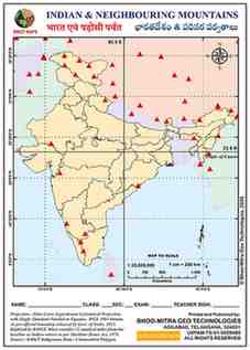
About This Map
A blank outline map of India and its neighbouring high-mountain region, for marking the subcontinent's great peaks — from Everest and Kangchenjunga on the Nepal border to K2 and Nanga Parbat in the Karakoram, and Nanda Devi and Kailash within India's own Himalayan and trans-Himalayan zone.
44 named peaks falling within this map's extent (≈ 5°N–39°N, 68°E–98°E), ordered highest to lowest
| Name | Elevation (m) |
|---|---|
| Mount Everest | 8848 |
| K2 | 8611 |
| Kanchenjunga | 8586 |
| Dhaulagiri | 8172 |
| Nanga Parbat | 8125 |
| Nanda Devi | 7817 |
| Batura Mustagh I | 7795 |
| Namcha Barwa | 7782 |
| Tirich Mir | 7708 |
| Kongkoerh | 7649 |
| Gangkar Punsum | 7570 |
| Pik Imeni Ismail Samani | 7495 |
| Nowshak | 7492 |
| Gyala Peri | 7294 |
| Liushi Shan | 7167 |
| Nyainqentanglha Feng | 7162 |
| Nun | 7135 |
| Lunpo Gangri | 7095 |
| Kangtö | 7060 |
| Muztag Feng | 6973 |
| Shahi Kangri | 6934 |
| Purog Kangri | 6929 |
| Bairiga | 6882 |
| Ak Tag | 6748 |
| Kangju Kangri | 6725 |
| Nganglong Kangri | 6720 |
| Kailash | 6638 |
| Geladandong | 6621 |
| Hkakabo Razi | 5881 |
| Kangze'gyai | 5808 |
| Sikaram | 4755 |
| Saramati | 3826 |
| Obasta Tsukai | 3452 |
| Mount Victoria | 3053 |
| Kennedy Peak | 2703 |
| Anai Mudi | 2695 |
| Doda Betta | 2636 |
| Pidurutalagala | 2524 |
| Guru Sikhar | 1722 |
| Salher | 1567 |
| Mahendra Giri | 1501 |
| Kodachadri | 1343 |
| Mowdok Mual | 1052 |
| Kabbal Durga | 921 |
Tips And Tricks
- Group the peaks by range rather than by height — the Karakoram (K2, Nanga Parbat) in the northwest, the Great Himalaya (Everest, Kangchenjunga, Annapurna, Dhaulagiri) along the Nepal border, and the Kumaon/Garhwal peaks (Nanda Devi, Trisul) within Indian territory.
- Of the peaks usually tested, only Kangchenjunga and Nanda Devi sit entirely within India — Everest, K2, Nanga Parbat, Annapurna and Dhaulagiri all lie in neighbouring countries, which is exactly the distinction most exam questions check for.
Comments & Issue Reporting
Sign in to leave a comment or report an issue with this map.
No comments yet — be the first to share your thoughts.