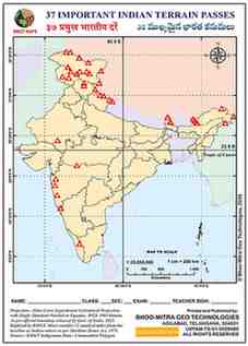
About This Map
A blank India outline map for marking all 37 major mountain passes tested in competitive-exam geography — from Umling La (5,799 m, Ladakh), the world's highest motorable road, down to the Palakkad Gap (230 m) that cuts clean through the Western Ghats. Nearly a third of the passes sit in the Northeast and Ladakh alone, reflecting how much of India's pass geography is concentrated along its Himalayan and trans-Himalayan frontier.
All 37 mountain passes, ordered highest to lowest
| Name | State / UT | Range | Elevation (m) | Connects |
|---|---|---|---|---|
| Umling La | Ladakh | Changthang | 5799 | World's highest motorable road, near Demchok |
| Mangsha Dhura | Uttarakhand | — | 5670 | Kuthi Valley, Kailash-Mansarovar route |
| Mana Pass | Uttarakhand | Garhwal Himalayas | 5610 | Near Badrinath, Nanda Devi Biosphere Reserve |
| Karakoram Pass (Qara Tagh La) | Ladakh/Xinjiang | Karakoram Range | 5540 | Ladakh-Xinjiang, Silk Route |
| Lanak La | Ladakh (Aksai Chin) | — | 5427 | Ladakh-Tibet (claimed border) |
| Chang La | Ladakh | Ladakh Range | 5360 | Leh-Shyok Valley/Pangong Tso |
| Khardung La | Ladakh | Ladakh Range | 5359 | Leh-Nubra/Shyok Valley |
| Lipu Lekh Pass | Uttarakhand | — | 5334 | India-Nepal-China tri-junction, Kailash Yatra |
| Naku La | Sikkim | — | 5259 | North Sikkim-Tibet |
| Niti Pass | Uttarakhand | — | 5070 | Ancient India-Tibet trade route |
| Parpik Pass | Ladakh/Xinjiang | Karakoram Range | 4978 | East of Mintaka Pass |
| Bara Lacha La | Himachal Pradesh | Zanskar Range | 4890 | Lahaul (HP)-Leh (Ladakh), Leh-Manali Hwy |
| Aghil Pass | Ladakh/Xinjiang | Karakoram Range | 4805 | Ladakh-Xinjiang (China) |
| Mintaka Pass | Ladakh/Xinjiang | Karakoram Range | 4709 | Near India-China-Afghanistan tri-point |
| Bum La | Arunachal Pradesh | — | 4600 | Tawang-Tsona County (Tibet) trade point |
| Diphu Pass | Arunachal Pradesh | — | 4587 | India-China-Myanmar tri-junction (McMahon Line) |
| Pensi La | Ladakh | Great Himalayas | 4400 | Suru Valley-Zanskar Valley (Gateway to Zanskar) |
| Nathu La | Sikkim | Dongkya Range | 4310 | Kalimpong/Gangtok-Chumbi Valley (India-China trade) |
| Jelep La | Sikkim | Dongkya Range | 4267 | Sikkim-Lhasa via Chumbi Valley |
| Sela Pass | Arunachal Pradesh | — | 4170 | Tawang-West Kameng (NH13) |
| Fotu La (Photu La) | Ladakh | Zanskar Range | 4108 | Highest pt Srinagar-Leh Hwy |
| Burzil Pass | Jammu and Kashmir | — | 4100 | Astore Valley-Deosai Plains |
| Rohtang Pass | Himachal Pradesh | Pir Panjal Range | 3978 | Kullu Valley-Lahaul & Spiti |
| Shipki La | Himachal Pradesh | — | 3930 | India-China border trade point, Kinnaur |
| Yonggyap (Yangyap) Pass | Arunachal Pradesh | — | 3876 | Arunachal Pradesh-Tibet |
| Zoji La | Ladakh/J&K | Zanskar Range | 3528 | Srinagar-Kargil-Leh (NH1) |
| Pir Panjal Pass (Peer Ki Gali) | Jammu and Kashmir | Pir Panjal Range | 3490 | Srinagar-Rajouri/Poonch (Mughal Road) |
| Banihal Pass | Jammu and Kashmir | Pir Panjal Range | 2832 | Jammu-Srinagar |
| Bomdi La | Arunachal Pradesh | — | 2217 | Tawang-Bomdila (NH13) |
| Haldighati Darra | Rajasthan | Aravalli Range | 1184 | Rajsamand-Udaipur; Battle of Haldighati 1576 |
| Pangsau Pass | Arunachal Pradesh | Patkai Hills | 1136 | India-Myanmar (Stilwell/Ledo Road) |
| Chorla Ghat | Goa/Karnataka/Maharashtra | Western Ghats (Sahyadri) | 800 | Goa-Karnataka-Maharashtra tri-junction |
| Asirgarh Pass | Madhya Pradesh | Satpura Range | 654 | Narmada-Tapti valleys; 'Key to the Deccan' |
| Kumbharli Ghat | Maharashtra | Western Ghats | 625 | Chiplun (Ratnagiri)-Karad (Satara) |
| Bhor Ghat | Maharashtra | Western Ghats | 622 | Khopoli-Khandala / Palasdari-Khandala (rail) |
| Thal Ghat (Kasara Ghat) | Maharashtra | Western Ghats | 585 | Mumbai-Nashik route |
| Pal Ghat (Palakkad Gap) | Kerala/Tamil Nadu | Western Ghats | 230 | Coimbatore (TN)-Palakkad (Kerala) |
Tips And Tricks
- Learn the passes in three altitude bands rather than alphabetically — trans-Himalayan passes above 4,500 m, mid-Himalayan passes, and the low Western Ghats gaps — since altitude band is what most exam questions actually test.
- The Palakkad Gap is the only pass on this map that isn't part of the Himalayan system at all — it's a break in the Western Ghats, and it's the reason Kerala's climate differs so much from Tamil Nadu's just across it.
Comments & Issue Reporting
Sign in to leave a comment or report an issue with this map.
No comments yet — be the first to share your thoughts.