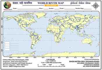
About This Map
A blank world outline map for tracing the planet's major river systems by continent, covering every system tested in school and competitive-exam geography — from the Nile and Amazon to the Ganga-Brahmaputra, Yangtze, and Mississippi-Missouri.
Tips And Tricks
- Trace rivers by continent, not by length — group the Nile, Congo, Zambezi and Niger as Africa's four majors, then the Ganga-Brahmaputra, Indus, Mekong, Yangtze and Yellow River as Asia's. Five regional clusters are far easier to hold in memory than fifty individual lines.
- Wherever a river's course runs through a lake — the Nile through Lake Victoria, or the Angara through Lake Baikal — the map shows a centerline rather than a gap. Draw straight through the lake rather than stopping at its shore.
- Separate exterior drainage (reaches an ocean) from interior/endorheic drainage (dead-ends in a landlocked basin) — the Volga into the Caspian Sea and the Amu Darya/Syr Darya into the shrinking Aral Sea are the classic endorheic examples exams like to test.
- Don't assume every major river flows toward the equator — the Ob, Yenisei and Lena in Siberia and the Mackenzie in Canada all flow north into the Arctic Ocean, the opposite of what most students first assume.
- Anchor each river at its mouth or delta, not just its source — the Ganga-Brahmaputra's Sundarbans, the Mississippi's delta near New Orleans, and the Nile's delta at the Mediterranean are exactly the landmark points most competitive-exam questions target.
Comments & Issue Reporting
Sign in to leave a comment or report an issue with this map.
No comments yet — be the first to share your thoughts.