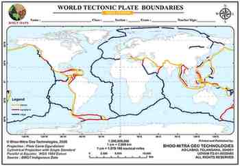
About This Map
A blank world outline map for tracing all three plate-boundary types — divergent (ridges), convergent (trenches / subduction zones), and transform (strike-slip faults) — built from a 514-segment global boundary dataset covering 219 individually named structures, from the Mid-Atlantic Ridge to the San Andreas Fault and the Mariana Trench.
Continents and their parent tectonic plate(s)
- Asia - Eurasian Plate (main body); Indian Plate (Indian subcontinent); Arabian Plate (Arabian Peninsula); Philippine Sea Plate (parts of Southeast Asia)
- Europe - Eurasian Plate
- Africa - African Plate (mostly); Somali Plate (East African Rift zone, slowly splitting away)
- North America - North American Plate
- South America - South American Plate
- Australia - Australian Plate (also called the Indo-Australian Plate in older classifications)
- Antarctica - Antarctic Plate
Oceans and their parent tectonic plate(s)
- Pacific Ocean - Pacific Plate (covers most of the basin); Juan de Fuca Plate, Cocos Plate, Nazca Plate, Philippine Sea Plate (smaller plates along the margins)
- Atlantic Ocean - North American Plate and Eurasian Plate (north of the equator); South American Plate and African Plate (south of the equator) - split down the middle by the Mid-Atlantic Ridge
- Indian Ocean - Indian Plate, African Plate, Antarctic Plate, Australian Plate - these four meet at the Indian Ocean Triple Junction (Rodrigues Triple Point)
- Arctic Ocean - North American Plate and Eurasian Plate
- Southern Ocean - Antarctic Plate
Key note
- Continents and oceans don't map one-to-one onto plates - a single plate often carries both continental and oceanic crust together (e.g., the South American Plate carries the continent of South America plus the western floor of the South Atlantic), and some continents sit on more than one plate.
Tips And Tricks
- Trace the divergent (ridge) boundaries first — the Mid-Atlantic and East Pacific ridges are long, continuous lines that make the surrounding plate outlines obvious once drawn.
- The Himalayan collision (Indus-Tsangpo Suture Zone) is the one convergent boundary on this map with no ocean trench at all — continent has collided directly with continent, unlike every subduction zone elsewhere.
- Transform boundaries neither create nor destroy crust — they only shear it sideways — which is why most of them are short offsets stitching ridge segments together in a zig-zag, rather than one long line like the San Andreas.
- The 'Ring of Fire' is just the trench line traced around the Pacific rim — draw the Aleutian, Japan, Philippine, Mariana and Peru-Chile trenches first and the earthquake/volcano clustering there becomes visual instead of a name to memorise.
- Hotspots like Hawaii or Yellowstone don't appear on this map at all — they sit in plate interiors, nowhere near a boundary — so don't mistake a hotspot volcanic chain for a plate edge if a textbook diagram shows one nearby.
Comments & Issue Reporting
Sign in to leave a comment or report an issue with this map.
No comments yet — be the first to share your thoughts.