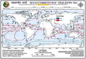
About This Map
A blank world outline map for tracing every major ocean current system — warm currents flowing poleward, cold currents flowing back toward the equator — across the Pacific, Atlantic, Indian and Southern Oceans. Built from a dataset covering every current named in the school and competitive-exam syllabus, from the Gulf Stream and Kuroshio to the Peru (Humboldt) and Benguela currents.
This map features 33 named currents across 74 line segments. Some currents, such as South Pacific and Alaska, are shown in more than one branch because their warm and cold portions are represented separately.
| No. | Warm currents | No. | Cold currents |
|---|---|---|---|
| 10 | North Equatorial | 1 | South Pacific |
| 12 | Eq. Countercurrent | 4 | West Wind Drift / Antarctic Circumpolar |
| 14 | South Equatorial | 5 | Falkland |
| 15 | East Australia | 6 | South Atlantic |
| 20 | Brazil | 8 | East Wind Drift / Antarctic Subpolar |
| 26 | Caribbean | 37 | Alaska |
| 28 | Agulhas | 44 | Oyashio |
| 38 | North Pacific | 47 | Transpolar Drift |
| 41 | Gulf Stream | 49 | Peru |
| 42 | North Atlantic | 54 | Benguela |
| 43 | North Atlantic/Azores | 55 | South Indian |
| 48 | Norwegian | 59 | South Indian/Western Australia |
| 51 | South Equatorial/South Pacific Gyre | 60 | California |
| 64 | Guinea | 63 | Canary |
| 74 | Kuroshio | 66 | Western Australia |
Tips And Tricks
- Coast rule: on every continent, west coasts get cold currents and east coasts get warm currents. That single idea covers the classic pairs like California and Canary versus Gulf Stream and Kuroshio, and also Peru/Benguela/Western Australia versus Brazil/Agulhas/East Australia.
- Clock rule: northern gyres spin clockwise and southern gyres spin counter-clockwise, so the warm currents are the ones pushed from the tropics toward the poles, while the cold currents are the ones pushed back from the poles toward the equator.
- Drift means cold: any current with 'Drift' in its name is slow, high-latitude, and cold — West Wind Drift, East Wind Drift, and Transpolar Drift are the easiest anchors.
- Atlantic chain: Gulf Stream warms the North Atlantic, Norwegian carries it north, Canary brings it back cold, North Equatorial pushes it west, Brazil carries it south warm, and Falkland brings it back cold.
- Pacific chain: Kuroshio warms Japan, North Pacific carries it east, California brings it back cold, South Equatorial pushes it west, East Australia carries it south warm, and Peru brings it back cold.
- Equatorial currents are always warm: North Equatorial, South Equatorial, and the Equatorial Countercurrent are warm even when their direction looks unusual. Polar names are cold by default: Oyashio, Labrador, East Greenland, and Falkland all belong to the cold side.
- Special anchors: Kuroshio and Oyashio sit on opposite sides of Japan, Norwegian is the warm tail of the Gulf Stream reaching the Arctic Circle, Guinea is the warm exception off west Africa, and South Pacific plus Alaska are transitional currents that change character along their route.
Comments & Issue Reporting
Sign in to leave a comment or report an issue with this map.
No comments yet — be the first to share your thoughts.